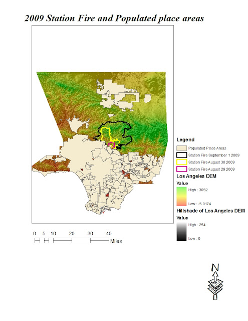
California is known for its wildfires. Because of this, every year, people do one or two things to make sure that they get prepared for the fires. The station fire of 2009 was one of the most devastating of wild fires in California. This fire was highly aided by California’s chaparral vegetation. According to inciweb.org, the station fire was the tenth largest fire in California since 1933 burning an area of 160,557 acres and the largest wild fire in the modern Los Angeles County, surpassing the 105,000 acre Clampitt Fire of September 1970. The station fire started on August 26th 2009 and lasted until October 16th 2009. A total of 209 structures were destroyed including 89 homes reported by inciweb.org. According to KTLA-TV, two firefighters were reported to be killed in the fire. The flames threatened a lot of structures in the Angeles National Forest and its nearby communities. These areas faced mandatory evacuation as the flames spread. According to officials, the station fire was started by arson.
According to inciweb.org, the predicted day for the station fires to be put out kept moving until the final extinction of the fire which occurred on October 16th 2009. It was very difficult to deal with the fire due to its enormosity. There were so many structures affected by the fire. The fire spread northwards from its origin in the southern side of the Angeles National Forest. In the northward direction, the spread was over mountainous terrain containing denser vegetation. It took firefighters about two months to contain the fire. This is goes a long way to indicate that this fire was aggressive and therefore dangerous.
My map focuses on the fact that most of the populated areas in Los Angeles County were out of the fire path even though the origin seemed a little populated. Looking at my thematic map, it can be seen that the fire originated in the southern portion of the Angeles National Forest and spread in the northward direction. To the south of the fire's origin, areas of high population density can be seen. The fire was a devastating one and it is with a sigh of relief that the endangered areas had less people. This made evacuation plans easier and accomodation affordable. One of the things that can explain this is the fact that the atmospheric conditions of this time period highly favored the fire. During the period of the station fire, the atmospheric conditions were hot and windy. Winds carry flames faster along its path. The fact that Los Angeles only experienced about 9.08 inches of rainfall between July of 2008 and June of 2009 played a great role in the fast spread of the fire, as pointed out by laalmanac.com. With the little rainfall, the environment wasn't moist enough to resist the fire, hence its spark and rapid growth.
With the fire only causing 22 casualties but consuming an area of 160,557 acres, it can be seen that there were not so many people in the path of the fire. Had it been that the fire consumed any of the areas south of its origin, where the population is denser, the casualty rate would have been higher. According to lacanadaflintride.com, 500 homes had lost electricity by september 1st. Electric lines carry flames fast and far. It will be devastating if this occured anywhere south of the fire's origin. It is also important to note that after wildfires, areas are vulnerable to mudslides. After the station fire, some of the areas were reported to have mudlides and debris flows during the first winter storms of the season. This was the case of Dunsmore Canyon which is one of the steep canyons that were affected by the fires. It experience a large amount of debris flow as reported by the USGS site. Such debris flows, mudslides and floods are usually due to exposion of the ground to running rain water due to the absence of plants. This flows are no joke because they can take out large populations and buildings. If the fire had consumed the highly populated areas of Los Angeles, the trouble would have been almost trippled.
All in all, it is important to look at the fact that due to Los Angeles' settlement pattern, the number of people affected by the fire wasn't large. It is a crucial thing to look at because even though a large amount of money had been spent to rebuild after the fire, much more would have been spent if the areas affected were any of the populated areas south of the fire's origin. This should be a sound warning for homeowners who in recent years have decided to move into sub-urban neighborhoods. The affected areas are all considered sub-urban and if people are actualy planning to move out to such places, they should be aware of the consequencies and disasters that come along.
CITATION
"Station Fire". inciweb.org. Inciweb the incident information system: Station Fire. 11 Nov.
2009. 23 Nov.2010. http://www.inciweb.org/incident/1856/7.
"Station Fire Victims Sue Farmers Insurance". ktla.com. Homeowners claim Farmers is refusing to pay for
smoke, ash and other damages to their homes. Aug 18 2010. 23 Nov 2010. <http://ktla.com/
news/landing/ktla-station-fire-farmers-insurance-lawsuit,0,5610248.story>
"Total Seasonal Rainfall (Precipitation) Los Angeles Civic Center, 1877-2009". laalmanac.com. Total
seasonal Rainfall 1877-Present. 2010. 23 Nov 2010. <http://
www.laalmanac.com/weather/we13.html>
"Station Fire". lacanadaflintridge.com. La Canada Flintridge. Sept 1 2009. 23 Nove 2010.
"2009 Station Fire Dunsmore Canyon Glendale California". usgs.gov. United States Geological Survey. April
30 2010. Nov 23 2010. http://landslides.usgs.gov/monitoring/dunsmore

No comments:
Post a Comment